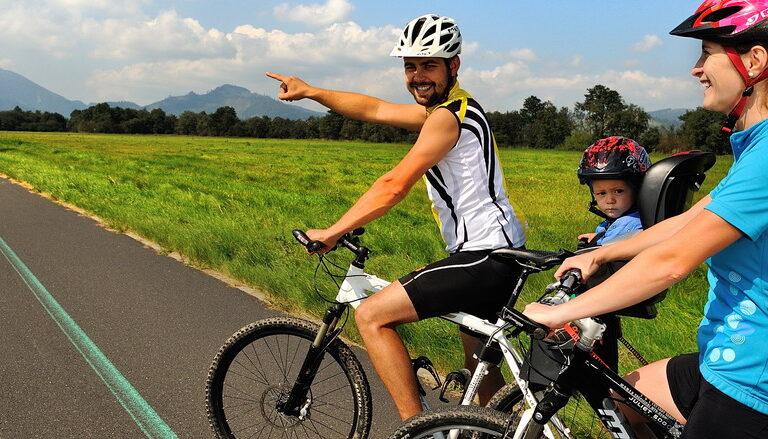
Cycling in the Tatras – adventures on two wheels
Experience more than 300 kilometres of marked cycle routes of various difficulty levels – from easy paths for families with children and beginners to adrenaline-filled mountain challenges below the Tatras peaks for fans of road and mountain biking as well as professional athletes.
Discover flat routes in the foothills, steeper climbs or an arterial cycle route encircling almost the whole foothills of the High Tatras.
Cyclotourism is a fantastic way to combine sport with a direct experience of nature.
Whether you’re a passionate cyclist or simply want to enjoy the scenery from your saddle – in the Tatras you’ll find the route that’s tailored for you. Explore the Tatras on two wheels!
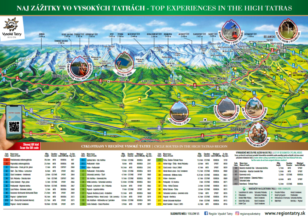
The High Tatras Region offers up to 39 marked or recommended cycle routes. Choose the right trip with the help of colour-coded signs indicating the level of difficulty:
mark long-distance cycle trails – cycle highways that pass through several districts and often across regions. They usually follow river valleys or mountain passes, taking cyclists through the most interesting parts of the region, with an emphasis on making them accessible. The most famous routes in the Tatras include:
| Colour | Name of track | Length | Character | Level of difficulty | Registration number |
|---|---|---|---|---|---|
| A1 | Podtatranská cyklomagistrála | 70.6 km | MTB | REKREA | 007 |
| A2 | Popradská cyklomagistrála | 25.4 km | MTB | REKREA | 008 |
indicate parallel trails to long-distance cycle highways. These are usually longer alternatives outside the main routes, or more demanding trails off arterial routes.
| Colour | Name of track | Length | Character | Level of difficulty | Registration number |
|---|---|---|---|---|---|
| B1 | Biela voda – Chata pri Zel. plese | 7.5 km | MTB | EXPERT | 2860 |
| B2 | Sibír – Žakovská Poľana – Gerlachov | 8.4 km | MTB | SPORT | 2863 |
| B3 | Starý Smokovec – Hrebienok | 2.8 km | ROAD | SPORT | 2864 |
| B4 | Tatranská Polianka – Sliezsky dom | 7 km | ROAD | EXPERT | 2865 |
| B5 | Cesta Slobody – Popr. pleso | 5.5 km | ROAD | SPORT | 2866 |
| B6 | Podbanské – Kôprová dolina | 10.8 km | ROAD | REKREA | 2867 |
| B7 | Lysá Poľana – Bielovodska dolina | 3.2 km | MTB | REKREA | 2868 |
| B8 | Huncovce-Kežmarok-Kežmarské Žľaby | 21.4 km | MTB | SPORT | 2869 |
| B9 | Poprad – Spišské Bystré | 10.3 km | MTB | REKREA | 2872 |
| B10 | Svit – Čierny Váh (horáreň Murná) | 22.7 km | MTB | SPORT | 2873 |
| B11 | Poprad – Horný Smokovec | 10.8 km | ROAD | SPORT | 2879 |
| B12 | Spišská Belá – Tatr. Kotlina | 9.9 km | ROAD | REKREA | 2887 |
| B13 | Podbanské – Hybe | 16 km | MTB | REKREA | 2341 |
| B14 | Hybe – Podbanské | 14.5 km | MTB | REKREA | 2342 |
mark medium and easy trails, health circuits and family-friendly routes.
| Colour | Name of track | Length | Character | Level of difficulty | Registration number |
|---|---|---|---|---|---|
| C1 | Podbanské – Tichá dolina | 12 km | ROAD | REKREA | 5859 |
| C2 | Tatranská Lomnica – Štart | 4.1 km | ROAD | SPORT | 5860 |
| C3 | Tatranská Kotlina – Slovenská Ves | 9.1 km | ROAD | REKREA | 5862 |
| C4 | Veľká Lomnica – Tatranská Lomnica | 12.4 km | ROAD | REKREA | 5863 |
| C5 | Poprad – Gerlachov – Tatranská Polianka | 16.6 km | MTB | SPORT | 5866 |
| C6 | Poprad – Lopušná dolina | 11 km | ROAD | SPORT | 5867 |
| C7 | Poprad- Kvetnica (Lom) – Hrabušice | 13.5 km | MTB | REKREA | 5868 |
| C8 | Žakovská Poľana – Nová Lesná – Tatranská Lomnica | 13.5 km | MTB | SPORT | 5879 |
| C9 | Tatr. Matliare – Križovatka na 7 potokov | 8.8 km | ROAD | REKREA | 5895 |
| C10 | Cesta Slobody – Chata Plesnivec | 3.9 km | MTB | SPORT | 5897 |
| C11 | Štrba, Šoldov-Štrbské Pleso | 12.4 km | ROAD | REKREA | 5910 |
indicate connections between cycle routes or short detours leading to natural, historical or technical points of interest.
| Colour | Name of track | Length | Character | Level of difficulty | Registration number |
|---|---|---|---|---|---|
| D1 | Vyšné Hágy – Štôla – Nová Polianka | 6.8 km | MTB | SPORT | 8858 |
| D2 | Stará Lesná – trasa č. 8860 | 4.1 km | MTB | SPORT | 8859 |
| D3 | Okruh Nová Lesná – Dol. Smokovec | 11.2 km | ROAD | REKREA | 8860 |
| D4 | Hrebienok – Bilíkova chata | 0.25 km | ROAD | REKREA | 8861 |
| D5 | Vrbov – Huncovce | 6.1 km | ROAD | REKREA | 8869 |
| D6 | Podspády – št. hranica | 3 km | ROAD | REKREA | 8871 |
| D7 | Štrba – Vyšná Šuňava | 2.4 km | ROAD | REKREA | 8872 |
| D8 | Nižná Šuňava – Štrba | 2.8 km | ROAD | REKREA | 8873 |
| D9 | Tatranská Lomnica – Javorová cesta | 1.9 km | MTB | SPORT | 8876 |
| D10 | Poprad – Kvetnica | 4.3 km | ROAD | REKREA | 8914 |
| D11 | Okruh Tatranské Matliare | 8 km | ROAD | REKREA | 8915 |
| D12 | Malý Slavkov – trasa č. 5895 | 6.2 km | MTB | REKREA | 8916 |
are those where cycling is permitted under the regulations of the Tatra National Park, but which do not have assigned registration numbers.
| Colour | Name of track | Length | Character | Level of difficulty |
|---|---|---|---|---|
| V4 | Náučný chodník Fľak – Tatranská Kotlina | 1,7 km | MTB | SPORT |
| V5 | Košariská – Náučný chodník Fľak | 1,6 km | MTB | SPORT |
| V7 | Kamenná cesta | 3,2 km | ROAD | REKREA |
| V11 | Dolný Smokovec – Žakovská Poľana – Tatranské Zruby | 4,6 km | MTB | SPORT |
| V17 | Kolečková – Štrbské Pleso | 9,2 km | ROAD | REKREA |
Read important information about the best cycle routes in the Tatras, details of individual routes and suggested 1-day trips.
Discover the sunlit Tatras from a bike saddle!


Implemented with the financial support of the Ministry of Tourism and Sports of the Slovak Republic.
Copyright 2026 Region Tatry.